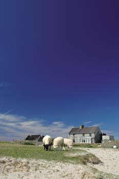

Illauntannig
Illauntannig maakt deel uit van een groep kalkstenen eilanden ten noorden van het schiereiland Dingle halverwege de westkust. Ze worden de Magharee eilanden of ook wel de Seven Hogs (Zeven Zwijnen) genoemd. Het vrij vlakke eiland is zo’n 14 hectare groot en bestaat uit boerenland, rotsen en zandstranden. Bij laag tij kunt u naar twee van de andere eilandjes lopen. Illauntannig was tot 1953 bewoond, nu kunt u er een accommodatie huren en heeft u het hele eiland voor uzelf.
Het betreft een voormalig boerenhuis met twee verdiepingen en een veranda. Het is geschikt voor zes tot acht personen, die in vier slaapkamers kunnen overnachten. Beddengoed is aanwezig. Voorts is er een zitkamer met een grote, stoere open haard, een keuken met alle benodigdheden, toilet en douche. Drinkwater en gas voor het fornuis, de koelkast en de douche worden geleverd. De verlichting bestaat uit olielampen. Voor de communicatie met het vasteland is er een radiozender. Indien u wilt, kunt u iedere dag naar het vasteland en terug worden gevaren. Dat duurt ongeveer tien tot twaalf minuten; de afstand is één zeemijl.
De stranden en het kristalheldere water zijn zeer geschikt en veilig om te zwemmen. Talrijke zeevogels strijken hier neer. Zover bekend is, was Illauntannig het enige van de zeven eilanden, dat bewoond werd. Al in de zesde eeuw bouwde St. Seanach (Oilean Seanaig) aan wie het eiland zijn naam ontleent, hier een klooster. De ruïnes zijn nog steeds te zien: een groot stenen kruis, een kerkje met een stenen altaar, grafmonumenten en een korte ondergrondse gang. Het uitzicht vanaf het eiland is magnifiek: naar het zuiden de baaien van Tralee en Brandon, alsmede Mount Brandon, naar het noorden de kust van het graafschap Clare en de monding van de Shannon. Er is een grote duikschool en een (wind)surfschool vlakbij op het vasteland.
Algemene informatie
Gesproken talen
Vakantiewoning o.b.v. zelfverzorging
Faciliteiten en activiteiten op locatie
Vuurplaats/barbecue
Faciliteiten en activiteiten in de omgeving (< 15 km)
Paardrijden
Windsurfen
Zeilen